Surpac is the world’s most popular geology and mine planning software used for ore body evaluation, open pit and u/g mine design.It provides tools for geological modelling, surveying, and mine planning.
The document discusses block modeling in Surpac software. It begins by defining block modeling and describing Surpac as mine planning software with various modules. It then outlines the objectives of block modeling in Surpac as familiarizing with its block modeling module, learning to fill a block model from drill hole data, apply constraints, and report volume, tonnage and grade. The document proceeds to explain the basic steps involved in block modeling and key concepts like model space, blocks and attributes, constraints, and estimation methods. It includes pictures demonstrating block models, borehole data display, and the Surpac interface. It concludes by providing an example workflow for creating a block model in Surpac.
This document introduces the theory behind geological database processes and provides detailed examples using the geological database modelling functions in Surpac. By working through this tutorial you will gain skills in the creation, use, and modification of geological databases.
Open pit mining is the process of mining a near surface deposit by means of a surface pit excavated using one or more horizontal benches. The term open pit mining is usually used for metallic or non-metallic deposits and sparingly used for bedded deposits like coal.
As a mining project is developed from conceptual to production phases, there exist a variety of uncertainties and difficulties that affect the operation’s designs and economic value. A notable design parameter to be taken into account is the factor of dilution. DILUTION Planned and Unplanned Dilution Internal and External Dilution Primary and Secondary Dilution Factors of Dilution Mine Value Diminutions Due to Dilution ORE RECOVERY Room and Pillar Example Ore Dilution & Recovery in Mining Rate of Extraction
Sublevel open stopping is a vertical mining method where a large open stope is created within an ore vein. Three variations are used: blast hole, open ending, and vertical crater retreat. Drilling is done from multiple sublevels using fan or parallel patterns. Ore is mucked using load haul dump equipment or slushers and transported to surface via skips or haul trucks. Pillars are left in place for support and ground conditioning uses bolts. Backfill allows for recovery of up to 90% of ore while providing support. It is suitable for moderate to strong ore bodies that are fairly steep, thick, and tabular in shape. Advantages include moderate productivity while disadvantages include complex development and inflexible planning.
Drilling is the process of making holes into hard surfaces like rock. In surface mining, drilling is used for blast hole drilling, core drilling for exploration, and technical drilling. Rotary blast hole drilling involves rotating drill pipes to which a bit is attached to break up rock. The main assemblies of a rotary drill rig include the mast, rod changer, rotary head, pull down mechanism, air compressor, drill pipes, hydraulic system, and dust control components.
This tutorial demonstrates how to create and work with geological databases in Surpac. Key steps covered include: 1. Creating DTMs from strings, spot heights, and a combination of breaklines and spot heights. 2. Setting up a new Surpac database by defining mandatory collar and survey tables, as well as optional tables for assays and geology. 3. Importing data, viewing tables, displaying and manipulating drillholes, creating sections, compositing, extracting data using domains, and displaying histograms. The tutorial provides a comprehensive introduction to building and utilizing geological databases in Surpac for tasks such as resource estimation and feasibility studies.
Choice of mining and processing methods; Choice of mining method; What determines the type of mining?; Types of Mining; Processes and Considerations; Surface and underground mining: what’s the difference?
Considerations on the sublevel stoping method; Conditions for application of the deposit; Characteristic of Sublevel Stoping Method; Application; Development; Sublevel overhand; Sublevel underhand; Slot; Configuration of stopes; Drawpoints
This document provides an overview of the Mineral Exploration and Evaluation course. It discusses the following key topics in mineral exploration: - Introduction to mineral resources and the historical background of mineral exploration. - Types, phases and sequences of mineral exploration planning and management. - Sampling and analytical techniques including sample preparation and laboratory methods. - Exploration methods such as geological mapping, geochemical and geophysical prospecting. - Presentation and interpretation of exploration data and resource evaluation including feasibility studies. It also provides details on various stages of mineral exploration including planning, reconnaissance, follow-up exploration, feasibility studies, construction and mine development, extraction, and mine closure.
Sampling is used to estimate grades and contents of materials in a deposit. The objective is to do this in an unbiased, precise manner. There are different sampling methods depending on the type of deposit, including core drilling, channel sampling, and trench sampling. Samples are analyzed to determine their physical and chemical characteristics, which provides information about the deposit for resource evaluation and process design.
Subsidence is one of the major environmental issues related to underground mining industry. This presentation gives an insight to causes, nature, effect of subsidence and some mitigation measures.
This document provides an outline for a lecture presentation on open pit mining methods and planning. It discusses key parameters such as bench height and geometry, cutoff grade calculation, and factors affecting open pit stability. The presentation covers the basic concept of open pit mining, how overburden is removed, and machinery used such as trucks, shovels, and drills. Diagrams illustrate typical bench terminology and pit slope angles. The importance of optimizing the pit design is addressed through considering elements like production scheduling, waste disposal, and ultimate pit limits.
The document discusses mine opening and development, focusing on box cuts. It defines a box cut as the initial cut made to physically develop a mine. Box cuts can be internal, located partially or fully within the mineralized zone, or external, located completely outside the mineralized zone. The key parameters of a box cut are its maximum level difference or height, which is usually equal to the proposed bench height, and its floor width, which must allow smooth machinery movement. Methods for opening a box cut include drilling and blasting or excavation by machinery like shovels. Factors in selecting a box cut location include site accessibility, excavation needs, dumping space, and the overall mine plan.
RMR, or Rock Mass Rating, is a method used to design support plans for underground mine workings based on characteristics of the rock mass. It involves assigning ratings for 5 parameters - layer thickness, structural features, weatherability, rock strength, and groundwater - to determine an overall RMR value. This value is then used to classify the roof rock, estimate expected rock loads, determine the required support resistance and number of roof bolts, and calculate support load density and theoretical strata convergence. The document provides examples of how RMR is applied to these design aspects at a depth of 300m for a mine in India.
Bucket wheel excavators are large continuous mining machines used for soft to semi-hard materials like clay, sand, gravel, and coal. They have a large wheel with buckets that removes material in a continuous process. The largest bucket wheel excavators can be over 90 meters tall and 240 meters long, with a 21-meter diameter wheel. They are commonly used in strip mining and lignite mining to continuously remove overburden and deliver large volumes of material.
Underground mining methods include room-and-pillar, longwall mining, sublevel caving and block caving. Longwall mining involves completely removing the entire coal seam in one operation by leaving no pillars and allowing the roof to cave. Factors that influence the selection of an underground mining method include the deposit's size, shape, depth and geology, geotechnical properties, economic considerations, available technology, and environmental concerns. The optimal mining method maximizes resource recovery while maintaining safety and minimizing costs and environmental impacts.
There are four main drilling methods: percussion, churn, diamond core, and rotary. Diamond core drilling is most useful for mineral exploration as it recovers intact core samples, allowing details about geology and mineralogy. Core logging involves examining core in boxes in geological order to record important rocks and structures. It is an important part of exploration analysis.
The document discusses surface mine planning and design. It covers factors that affect pit planning such as natural conditions, economics, and technology. The objectives of pit planning are to mine the ore body at minimum cost while maintaining operational viability. Both long-range planning, which determines final pit limits, and short-range planning in sequential steps are required. General considerations for planning include land reclamation, topsoil storage, and advance stripping. The selection of mining equipment depends on factors like the size and geometry of the ore body, production rates, and pit conditions.
Seismic surveys use seismic waves to image the subsurface. There are two main types: refraction surveys use refracted waves to determine shallow layer velocities, while reflection surveys use reflected waves to image deeper geological structures and boundaries between rock layers. Reflection surveys require more receivers and sources to adequately image the subsurface, making the data acquisition and processing more complex but able to image deeper targets compared to refraction surveys.
An open pit mine is an excavation made at the surface of the ground to extract ore throughout the life of the mine. Large quantities of waste rock must be excavated and relocated to access and mine the ore deposit. The planning of an open pit mine aims to exploit the mineral deposit at the lowest cost while maximizing profits, through optimizing the physical design and scheduling of ore and waste extraction. Ore and waste materials are removed in successive layers called benches, with several benches potentially in operation simultaneously at different elevations in the open pit mine.
Geological mapping involves systematically observing and recording rock exposures and structural features in the field to produce maps that show the spatial distribution and relationships of rock units. The document discusses different types of geological maps including reconnaissance, regional, detailed, and specialized maps. It also describes common mapping techniques such as traversing, exposure mapping, drilling, underground mapping, and photo-geology. Field equipment used in mapping includes hammers, chisels, compasses, clinometers, tapes, and notebooks.
This document provides an overview of geoprocessing, which allows users to define, manage, and analyze spatial information to support decision making. It discusses how geoprocessing works in ArcGIS through tools, models, scripts, and toolboxes. Specific geoprocessing tasks like overlay, proximity, surfaces, and statistics are examined. The document also covers data sources, running tools, and settings. It provides examples of creating a model and script to automate repetitive geoprocessing work.
This document provides instructions for accessing and using various GIS software tools remotely or locally, including ArcGIS Online, ArcGIS for Desktop, GeoDa, QGIS, and Google Earth Pro. It also lists some popular web GIS tools and programming libraries for creating web maps. Finally, it describes the major geoprocessing tools in GIS like buffers, clips, merges, dissolves, intersects, and unions; and provides steps for importing and exporting GIS data between AutoCAD and Revit software.
This document provides an overview of the key features and functionality of a web-based geographic information system (GIS). It describes the main components including databases, mapping capabilities, and interactive tools. The system allows users to search for and view property data, print maps, and export/import data in common formats. Detailed information and help documents are accessible through an online help button.
This document provides a tutorial for publishing a geoprocessing model as a service in ArcGIS Server. It describes building a simple model using the Buffer and Clip tools in ArcMap. The model buffers input points by a specified distance and clips the results to a coastline feature class. The document outlines setting the environment, building the model with variables, and publishing/running the model as a service to be accessed in web applications. It focuses on supported data types and using the server jobs directory to manage intermediate and output data.
The document provides steps for basic tasks in ArcGIS including adding data, adding symbology, creating buffers, and migrating data between a shapefile and geodatabase. It outlines 7 steps for adding shapefiles or feature classes to a map, 10 steps for applying symbology, and describes how to use buffer tools and wizards to create buffers around selected features at a specified distance. It also explains how to import and export data between a shapefile and geodatabase using geoprocessing tools.
This document provides instructions for installing and using SPHARM-PDM, a software for shape analysis, and ShapePopulationViewer, a tool for quality control of SPHARM-PDM outputs. It describes downloading required files, configuring inputs and outputs in the Shape Analysis module, running SPHARM-PDM to generate outputs including surface meshes and parameterizations, and viewing and comparing output files using 3D Slicer. It also outlines using ShapePopulationViewer to perform quality control on SPHARM-PDM correspondences between output shapes.
Potter's Wheel is an interactive tool for data transformation, cleaning and analysis. It integrates data auditing, transformation and analysis. The user can specify transformations by example through a spreadsheet interface. It detects discrepancies and flags them for the user. Transformations can be stored as programs to apply to data. It allows interactive exploration of data without waiting through partitioning and aggregation.
CALPUFF is a multi-layer, multi-species non-steady-state Lagrangian puff dispersion model recommended by the EPA for regulatory applications from tens to hundreds of kilometers. BREEZE CALPUFF provides a graphical user interface and productivity tools for CALPUFF and its meteorological and post-processing components. BREEZE 3D Analyst enables users to analyze and visualize modeling results in 2D and 3D, including contour plots, isosurfaces, and animations for presentations.
Software para maquinas dfe medicion por coordenadas Aberlink 3d datasheetDaniel Bezares
Aberlink 3D is measurement software designed around a graphical user interface to make measurement easy. It can be used on manual or CNC machines for 2D or 3D measurement with probing systems or vision. The software builds a picture of the component and allows dimensions to be taken directly from the picture. It generates inspection reports and SPC data that can be output in various formats. The software is designed to be intuitive and help guide users through the measurement process.
This document summarizes the contents and structure of the Global Mapper user manual. It provides instructions on how to download the software and manual, and access the manual offline. It also describes the software's registration process and limitations for the unregistered version. The summary covers the program toolbar and menus, including the File, Edit, View, Tools, Search, and Help menus and their main commands.
Spatial Data Integrator - Software Presentation and Use Casesmathieuraj
Spatial Data Integrator software is an open source ETL tool that adds spatial capabilities to Talend Open Studio for extracting, transforming, and loading geospatial data. It can be used to perform tasks like aggregating data from multiple sources, merging geographic layers, and chaining quality checks on digitized documents. The presentation demonstrated how to configure SDI, connect components, and execute jobs to perform these types of spatial data integration and management tasks.
School of Computing, Science & EngineeringAssessment Briefin.docxanhlodge
This document provides instructions for a computer graphics assignment involving the development of a solar system simulation using OpenGL. Students are asked to create a dynamic data structure to store planetary body objects and implement a physics simulation to model gravitational forces. The simulation should allow for random generation of bodies, collision detection, and user interaction. Assessment will be based on the design of the data structure, implementation of the simulation, rendering quality, and user interface. The goal is for students to demonstrate skills in C/C++ programming, OpenGL, and graphics principles.
The document discusses the Legacy System Migration Workbench (LSMW) in SAP, which is a tool used to transfer data from non-SAP legacy systems to an SAP R/3 system. It describes the basic principles, features, and steps of using LSMW, including maintaining source structures and fields, mapping fields, importing and converting data, and displaying the results. The main steps are creating an LSMW project, mapping source and target structures and fields, importing legacy data files, and converting the data for use in SAP.
A user's guide for a utility that creates defect wafer map images from klarf files. The program uses gnuplot to create the images. This program can be found at http://www.valaddsoft.com/Blog/products-2/
The Move CV tool is the primary tool for sculpting NURBS surfaces in Alias. It allows precise movement of control vertices (CVs) to shape the surface. Key features include: - Selecting individual or groups of CVs for movement - Constraining movement along U, V or both directions - Using snapping tools for accurate placement - Seeing live updates of the surface as CVs are moved - Diagnostics to check for errors introduced by movements The tool provides the precision and control needed for high-quality Class A surfacing work.
call for Papers - 6th International Conference on Natural Language Computing ...CSEIJJournal
6th International Conference on Natural Language Computing and AI (NLCAI 2025) will provide an excellent international forum for sharing knowledge and results in theory, methodology and applications of Natural Language Computing, and AI. The Conference looks for significant contributions to all major fields of the Natural Language processing and machine learning in theoretical and practical aspects.
DESIGN TACTILE INTERFACES WITH VIBRATION PATTERNS IN HTML5 FOR SMARTPHONE USE...johnmathew9417
This paper describes the procedure for creating tactile interfaces for Android smart phones. It uses the HTML5 Vibration API and the Javascript programming language to create vibration patterns in order to increase the interaction between visually impaired people with their smart phones.
Enhanced E-Commerce Demand Prediction through Ensemble Models and Optuna-Base...Ram Krishna
Conference: 2nd DMIHER International Conference on Artificial Intelligence in Education and Industry 4.0 Track: AI for Industry Speaker: Ramakrishna Garine This presentation showcases a powerful AI-driven framework for improving demand forecasting in e-commerce supply chains using an ensemble of advanced machine learning models. The study integrates Random Forest, LightGBM, and XGBoost, tuned via Optuna, to achieve superior accuracy and reduce forecast errors. Key contributions include: Ensemble Learning Strategy: Combines model strengths to reduce individual biases and enhance reliability. Hyperparameter Optimization with Optuna: Improves model performance significantly, reducing MAPE to 0.0336. E-Commerce-Specific Insights: Addresses data volatility and high dimensionality, typical challenges in online retail demand planning. Scalability & Future Potential: The framework is adaptable to broader supply chain environments and larger datasets. The session provides practical strategies for applying AI to streamline inventory management, reduce costs, and support agile decision-making in the fast-paced world of digital commerce.
The closure of the Narmada Main Canal (NMC) is essential for various operational and maintenance purposes to ensure its efficient and long-term functionality. One of the primary reasons for closing the canal is maintenance and repair work. Over time, silt, debris, and vegetation accumulate in the canal, reducing its discharge capacity. Periodic desilting and cleaning are necessary to restore optimal water flow. Additionally, the canal lining, expansion joints, embankments, and control structures such as gates and regulators require regular inspection and repair to prevent seepage, structural failures, or operational inefficiencies. Closure also facilitates the maintenance of bridges, cross-drainage works, aqueducts, and siphons along the canal. The closure of the Narmada Main Canal (NMC) is also necessary to address waterlogging issues in nearby villages like nagla ,dodgam,bhapi ,bhadodar. In certain areas, excessive seepage from the canal, combined with inadequate drainage systems, can lead to water accumulation in agricultural fields and residential areas. This prolonged waterlogging not only affects crop productivity but also damages infrastructure and creates health hazards for local communities. Proper planning and execution of canal closures help in maintaining a balance between water supply and environmental sustainability. Coordinated efforts between irrigation authorities, local governance bodies, and affected villagers ensure that waterlogging problems are effectively controlled while maintaining the canal’s operational efficiency. the first closure of the Narmada Main Canal (NMC) was scheduled from May 1, 2023 to May 15 2023, while the second closure took place from June 15, 2023, to June 30, 2023.
6th International Conference on Advances in Artificial Intelligence Techniques (ArIT 2025) will provide an excellent international forum for sharing knowledge and results in theory, methodology and applications of Artificial Intelligence and its advances. The Conference looks for significant contributions to all major fields of the Artificial Intelligence in theoretical and practical aspects. The aim of the Conference is to provide a platform to the researchers and practitioners from both academia as well as industry to meet and share cutting-edge development in the field
PRIZ Academy - Root Cause Analysis (RCA) Quality Assurance with PRIZ .pdfPRIZ Guru
Learn how to shift Quality Assurance from costly “detect-and-fix” firefighting to proactive “predict-and-prevent” excellence. This deck—taken from our April 2025 PRIZ Academy webinar—explains modern Root-Cause Analysis, shares a real microchip-manufacturing success story, and shows how the PRIZ Engineering-Thinking Platform unifies CEC, functional modelling, and action tracking to cut defects, rework, and downtime.
E-BOOK MANAGEMENT.pptx using Object oriented software engineeringraghaviarumugam14
An eBook management system is a software application designed to organize, store, and manage digital books. Here's a detailed overview: *Key Features:* 1. _Cataloging_: Allows users to create a catalog of eBooks, including metadata such as title, author, genre, and publication date. 2. _Organization_: Enables users to organize eBooks by categories, tags, or collections. 3. _Search_: Provides a search function to find specific eBooks by title, author, or keyword. 4. _Storage_: Stores eBooks in a digital format, allowing users to access them from various devices. 5. _Access Control_: Offers features to control access to eBooks, such as user authentication and authorization. 6. _Metadata Management_: Allows users to edit and manage metadata associated with eBooks. 7. _Reporting_: Generates reports on eBook usage, circulation, and other relevant metrics. *Benefits:* 1. _Efficient Management_: Streamlines the process of managing large collections of eBooks. 2. _Easy Access_: Provides users with easy access to eBooks from various devices. 3. _Improved Discovery_: Enhances discovery of eBooks through search and recommendation features. 4. _Cost-Effective_: Reduces costs associated with physical book storage and management. *Types of eBook Management Systems:* 1. _Library Management Systems_: Designed for libraries to manage their eBook collections. 2. _Personal eBook Management_: Designed for individuals to manage their personal eBook collections. 3. _Digital Publishing Platforms_: Designed for publishers to manage and distribute their eBooks. *Examples:* 1. _Calibre_: A popular open-source eBook management software. 2. _OverDrive_: A digital distribution platform for libraries and schools. 3. _Adobe Digital Editions_: A digital rights management (DRM) solution for eBooks. *Considerations:* 1. _Compatibility_: Ensure the system is compatible with various eBook formats and devices. 2. _Security_: Ensure the system provides adequate security measures to protect eBooks and user data. 3. _Scalability_: Choose a system that can scale to meet the needs of your growing eBook collection. Would you like to know more about a specific aspect of eBook management systems or explore other topics? I'm here to help!Let's dive deeper into eBook management systems. *Key Components:* 1. _Digital Library_: A centralized repository for storing and managing eBooks. 2. _Metadata Management_: A system for managing metadata, such as title, author, and genre. 3. _Search and Discovery_: Features that enable users to find eBooks through search, recommendations, and browsing. 4. _Access Control_: Mechanisms to control access to eBooks, including user authentication and authorization. 5. _Reporting and Analytics_: Tools to track eBook usage, circulation, and other relevant metrics. *Benefits for Libraries:* 1. _Increased Accessibility_: eBook management systems provide patrons with 24/7 access to eBooks. 2. _Streamlined Collection Management_: Automate tasks, such as
Transportation Design at Ajeenkya DY Patil Univeristysourabhmore19
Transportation Design is the creative and technical process of designing vehicles and mobility systems—from cars and bikes to aircraft and public transport. It blends aesthetics, innovation, and functionality to shape how people move, focusing on sustainability, user experience, and future technologies like EVs and autonomous mobility.
3. What is Surpac? Geocom Surpac is the world’s most popular geology and mine planning software. Surpac is a comprehensive system for ore body evaluation, open pit and u/g mine design. It provides tools for geological modelling, surveying, and mine planning. Surpac Vision is an analysis and design tool, which provides flexibility and numerous options with the integration of a 3D graphical environment containing multi layer control and split screen viewports. Surpac Vision version 5.0 has a range of excellent new functionality in key areas.
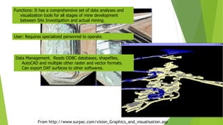
4. From http://www.surpac.com/vision_Graphics_and_visualisation.asp Functions: It has a comprehensive set of data analyses and visualization tools for all stages of mine development between Site Investigation and actual mining. Data Management. Reads ODBC databases, shapefiles, AutoCAD and multiple other raster and vector formats. Can export DXF surfaces to other softwares. User: Requires specialized personnel to operate.
5. Software Analysis/ Visual tools Users Data Management Geosoft Oasis Montage Critical, but not many Need technical specialist Proprietary data, but good interface Arc View w/ 3D Analyst Many, but Not all. User Friendly Reads ODBC, DXF multiple raster and grid formats Surpac Vision Almost everything Need tech. specialist/prof review. Reads(Arc)Shape ODBC, multiple raster and grid formats acQuire Minimal Functions Training/Data Management Specialist Provides all levels of Data Management Rockware Many, almost All Requires reading of manuals Reads MDB, and ArcGIS Interface.
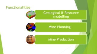
7. GEOLOGICAL AND RESOURCE MODELING Data Management Employ sophisticated database tools to store, manage and review drilling data. Interface to any popular database product and work in real time while connected to that data. View and output sections quickly and easily using drillholes and existing topographic or pre-modeled data.
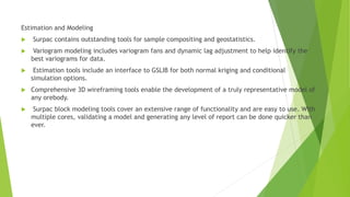
8. Estimation and Modeling Surpac contains outstanding tools for sample compositing and geostatistics. Variogram modeling includes variogram fans and dynamic lag adjustment to help identify the best variograms for data. Estimation tools include an interface to GSLIB for both normal kriging and conditional simulation options. Comprehensive 3D wireframing tools enable the development of a truly representative model of any orebody. Surpac block modeling tools cover an extensive range of functionality and are easy to use. With multiple cores, validating a model and generating any level of report can be done quicker than ever.
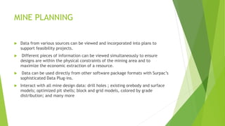
9. MINE PLANNING Data from various sources can be viewed and incorporated into plans to support feasibility projects. Different pieces of information can be viewed simultaneously to ensure designs are within the physical constraints of the mining area and to maximize the economic extraction of a resource. Data can be used directly from other software package formats with Surpac’s sophisticated Data Plug-ins. Interact with all mine design data: drill holes ; existing orebody and surface models; optimized pit shells; block and grid models, colored by grade distribution; and many more
10. MINE PRODUCTION Mine Survey and Ore Control Calculate and validate volumes quickly. Compare kriged models against raw drillhole data to optimize reserve extraction. Produce high quality to-scale maps of any relevant project information. Road and pit design tools are geared towards surveying setout, ensuring the necessary details required by earth movers are marked out accurately. Integrated resource models, pit designs and survey data results in up-to-date ore markouts and dig plans with grade and tonnage reports.
11. Benefits • Better sharing of data, skills and project knowledge increases efficiencies within teams. • Tasks in Surpac can be automated for compliance with company-specific processes and data flows for increased time savings and consistency of execution. • Software ease-of-use quickly ensures staff develops an understanding of the system and project data quickly. • Surpac is modular and easily customized to adapt to changing needs. • Surpac reduces data duplication and interfaces with common file formats from GIS, CAD and other systems. • Multilingual support: English, Chinese, Russian, Spanish and French.
12. THE SURPAC PLATFORM Main Window The main window is where all the ”work” gets done. It is important that you understand how to use the various features of this window to get the maximum benefit from the software.
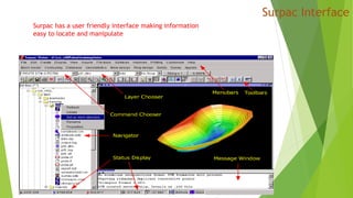
14. Menu Bar: There are 11 different menus to choose from in Surpac Vision. The two defaultmenus are called Main Menu & Applications Menu. Others include Applets, Blast Design,Block Model, Database, Mine Design, Ring Design, Solids, Surveying, & Scheduling. Toolbars: There are 14 different toolbars to choose from in Surpac. The two defaulttoolbars are called Status Items, & Main. Others include Edit, Create, Display/Hide,View, Inquire, File Tools, Block Model, Database Mine Design, Blast Design, RingDesign, & Scheduling. Menus or Toolbars may be displayed or removed by right-hand clicking any region withno menu item and selecting or de-selecting the menus/toolbars from the subsequentcontext menu. Menus are located above the separator line in the context menu, andtoolbars below
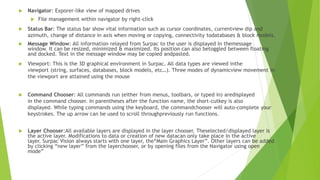
15. Navigator: Exporer-like view of mapped drives File management within navigator by right-click Status Bar: The status bar show vital information such as cursor coordinates, currentview dip and azimuth, change of distance in axis when moving or copying, connectivity todatabases & block models. Message Window: All information relayed from Surpac to the user is displayed in themessage window. It can be resized, minimized & maximized. Its position can also betoggled between floating and docked. Text in the message window may be copied andpasted. Viewport: This is the 3D graphical environment in Surpac. All data types are viewed inthe viewport (string, surfaces, databases, block models, etc…). Three modes of dynamicview movement in the viewport are attained using the mouse Command Chooser: All commands run (either from menus, toolbars, or typed in) aredisplayed in the command chooser. In parentheses after the function name, the short-cutkey is also displayed. While typing commands using the keyboard, the commandchooser will auto-complete your keystrokes. The up arrow can be used to scroll throughpreviously run functions. Layer Chooser:All available layers are displayed in the layer chooser. Theselected/displayed layer is the active layer. Modifications to data or creation of new datacan only take place in the active layer. Surpac Vision always starts with one layer, the“Main Graphics Layer”. Other layers can be added by clicking “new layer” from the layerchooser, or by opening files from the Navigator using open mode”
16. CURRENT WORKING DIRECTORY The current working directory is the directory path “set” within surpac to which all subsequent files are saved. This directory is displayed in the uppermost title bar of the SURPAC Vision window
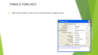
17. FORMS & FORM HELP right mouse button in the current field presents a popup menu:
18. Last Values The five values previous entered in the field are displayed. Selecting one of these values copies it into the current field. Following these items is Last value for all fields. Selecting this item reverts every field on the form to its value the last time the form was applied
20. Field Help, Form Help Auto Help Field Help Selecting this item displays the field help for the current field. The field help information automatically updates for any later selected fields. When the form is closed, the help will not re-appear for subsequent forms, unless this menu option is selected again. Form Help Selecting this item displays the form help for the current form. When the form is closed, the help will not re-appear for subsequent forms, unless this menu option is selected again. Auto Help Selecting Auto help makes the form and field help window appear for every form until you either select it again, or shut down the software.
21. Last Value if blank This causes the field to retain the last value entered where the application does not supply a value. For example, if selected for the Layer field of the Recall a File form, this option would not alter the field, but if selected for the Location field of the same form, the last file location would be presented. Last Value Selecting this item causes the field to retain the last value regardless of any other value inserted by the application. For example, if selected for the Layer field of the Recall a File form, this option would present the name of the layer the previous application of this form used. Constant... Selecting this item allows entry of a value to use for this field every time the form is displayed. Application Selecting this item causes the field to behave in the same way that it did in previous versions of the software, displaying any value entered in the field by the application
22. Function Keys Key Name Physic al Key Functionality Apply F2 Enter Invoke a function entered in the Command Chooser. Complete a form. Help F3 On-line help. Press the F3 key or single click the Help button to will invoke the on-line help with the page being displayed relating to the form that is currently displayed, or the function that is currently executing. Cancel Esc Cancel the current form. Escape from a selection browser. Abort Ctrl-c Abort the function or macro. Pushing the abort button (on the progress feedback bar) will abort the current function Tab Tab Advance to the next input field. BACK_ TAB Shift- tab Move to the previous field, or to the previous column on the same row if inside a scrolling region. Selected keys on the keyboard are defined so that various actions can be performed. These keys are:
23. Customizing Surpac Surpac Vision will start in the default installation directory. Take note of this startup directory, it is displayed in the window header at the top of the screen and is represented by a tick in the file navigator. To customize the startup directory, exit out of surpac and right click on the surpac icon, select the properties tab Useful things to change at this stage are: The startup directory Icon colour Shortcut key
24. Menu and Toolbar Customisation CREATING A PROFILE: Profile is a configuration of menus and toolbars that have been designed to suit a particular style of usage of the software. A number of suitable profiles are provided. You can, using the customising features of the software create your own profiles to suit your own usage pattern.
25. Main Window: The main window is where all the ”work” gets done. The main window has four major components: Menus Graphics Window Message Window Surpac Navigator
26. Menu The File menu contains functions for loading and saving string files and DTM files. You will use the Save File function most commonly, to save DTM and string files. However you can also capture screen images using the Postscript and GIF or PNG Dump functions. FILE MENU
27. Edit Layers The Edit | Layers menu contains some very useful features of Surpac Vision i.e. the ability to use and manipulate data in multiple layers. .
28. Display Menu The Display menu allows you to nominate how to display your data on screen Use the toolbar. or the Pull down menu to Display and Hide String and DTM data in Graphics.
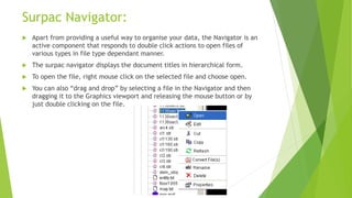
29. Surpac Navigator: Apart from providing a useful way to organise your data, the Navigator is an active component that responds to double click actions to open files of various types in file type dependant manner. The surpac navigator displays the document titles in hierarchical form. To open the file, right mouse click on the selected file and choose open. You can also “drag and drop” by selecting a file in the Navigator and then dragging it to the Graphics viewport and releasing the mouse button or by just double clicking on the file.
30. DTM TOOLS Surfaces in SURPAC are modelled as DTM's (digital terrain models). DTM's may be generated from many different types of data such as surface topography, bedrock topography, & geological contacts. Accurate volume calculations between DTM's are one of SURPAC's strongest capabilities.
32. UNDERGROUND MINE DESIGN Surpac Vision has many functions for underground mine design and is applicable to such underground engineering tasks as solid modelling underground workings, production & development layout design, ring/blast design, and maintaining survey data. DRILLHOLE DATABASE Surpac has the capability to read and create any ODBC database including MS Access. A geology database will contain many types of drill hole data such as lithology, & assays. It forms the basis of a reserves estimation. These data are easily imported through SURPAC's importing functions.
33. Importing Data Formats • Surpac has its own file formats, however support is offered for files from other software packages. • There are two methods for reading or writing these files Using the importing/exporting tools Using the data plugins module
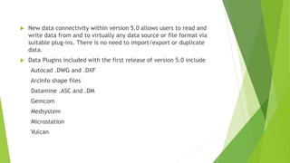
34. New data connectivity within version 5.0 allows users to read and write data from and to virtually any data source or file format via suitable plug-ins. There is no need to import/export or duplicate data. Data Plugins included with the first release of version 5.0 include Autocad .DWG and .DXF ArcInfo shape files Datamine .ASC and .DM Gemcom Medsystem Microstation Vulcan
35. Importing and Exporting Files can be imported into a Surpac format via functionality through the menus. The files are physically converted into the Surpac format. Supported Formats are: Autocad DXF/DWG files ArcView / ArcInfo files Datamine files Moss Genio files Microlynx files Likewise, Surpac files can be exported into the above formats
36. Data Plugins Data from other packages can be used in Surpac through the enabling of the Data Plugins module. This allows drag and drop capability and conversion of the following file types. ArcInfo shape files (.shp) Autocad files (.dxf, .dwg) Datamine files (.dm, .asc, .ddf, .dat) Gemcom files (.3dr, .bt2, .tie, .abp, .stl) Vulcan files (.dgd, .00t) Microstation files (.dgn) Minesight files (.msr) Mapinfo files (.tab, .mif)
37. Functionality of Data Plugins Data is dragged and dropped into the Surpac workspace Data remains in its native format when manipulated Data can be saved in any of the other formats Data can be converted into any of the other formats without opening the file Plugins are constantly maintained as other software companies update their own format
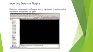
38. Importing Data via Plugins Data can be brought into Surpac simply by dragging and dropping one of the recognised file types.